An extended four-weeks trek through the most famous part of the Himalayas.
See also a nice report of someome who did the core of the same Khumbu loop in opposite direction.
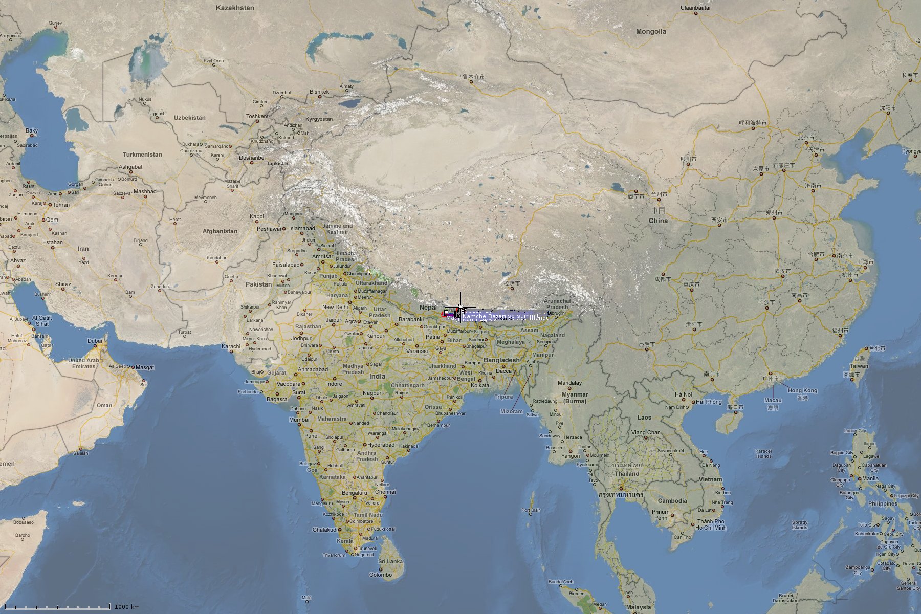
Before and after the trekking tour, I spent a couple of days in Kathmandu and its vicinity.
All my photos presented here are geo-tagged with the data mentioned below.
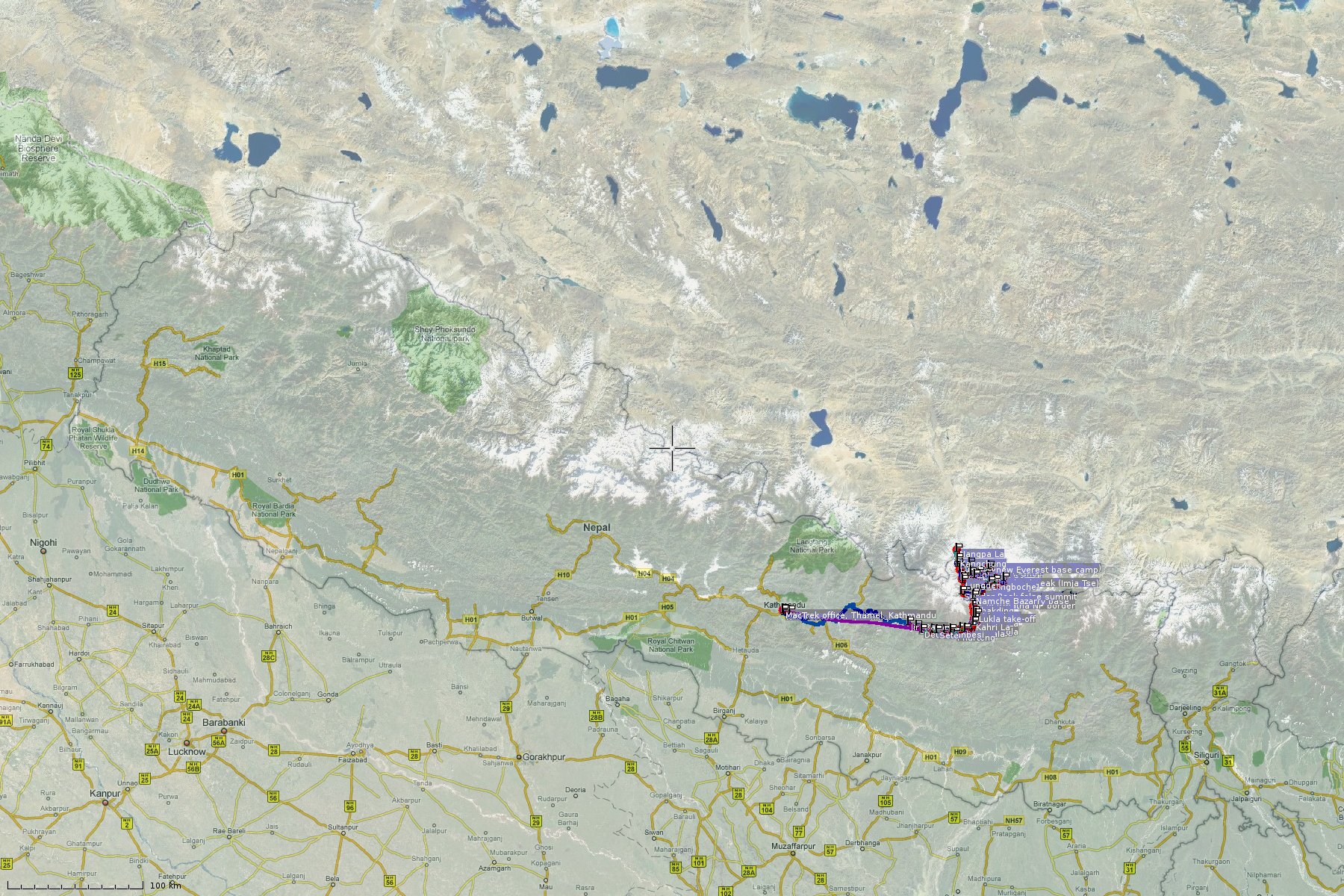
A GPS recording of my route is available for download as GPX file or
KML file for Google Earth.
It can be directly viewed on Google Terrain Maps (including waypoints) and on GPSies (including waypoints and statistics).
I collected the GPS data with a Holux m241 GPS logger. During days 2-6, the device did not properly store the track data or the data got corrupted thereafter, such that I had to manually reconstruct the trail data, which I did in a rather coarse fashion. For this reason, and also because of its high battery consumption and relatively inconvenient handling, I cannot really recommend this cheap (60 USD) device.
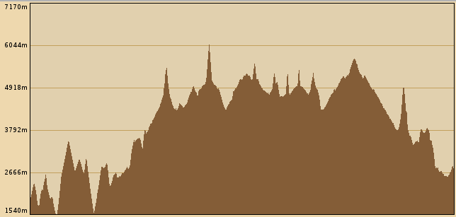
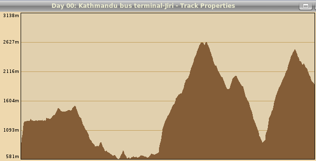
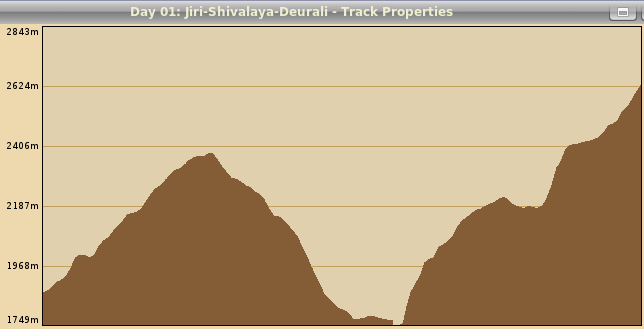
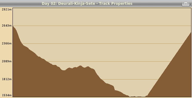
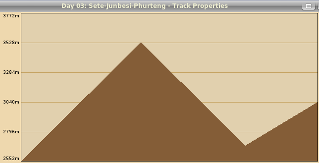
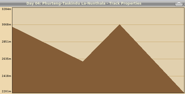
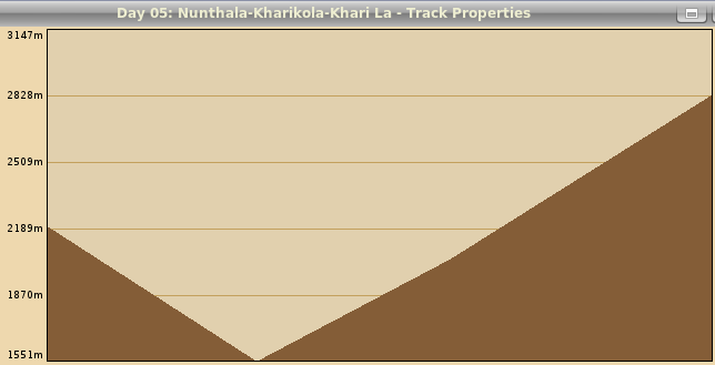
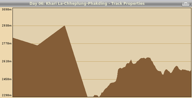
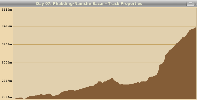
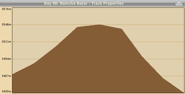
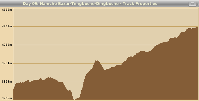
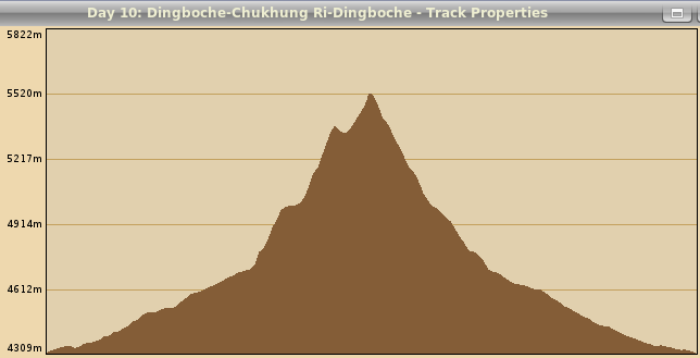
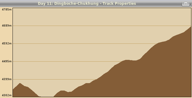
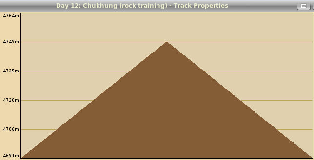
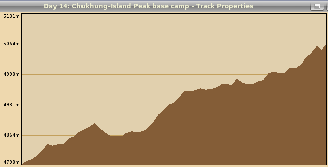
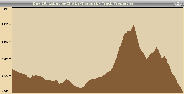
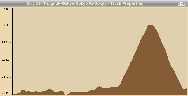
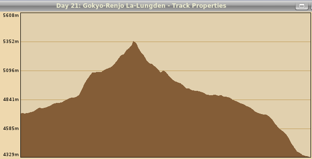
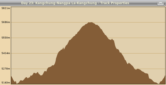
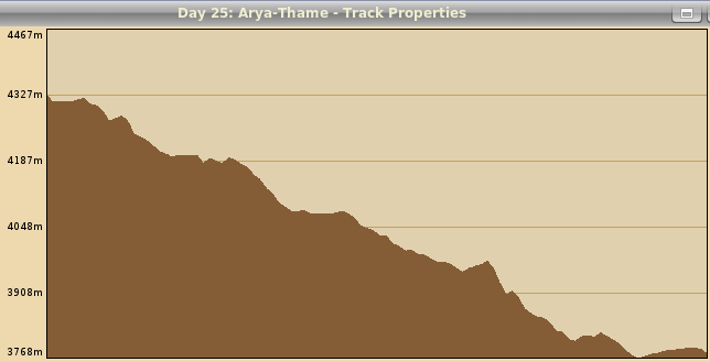
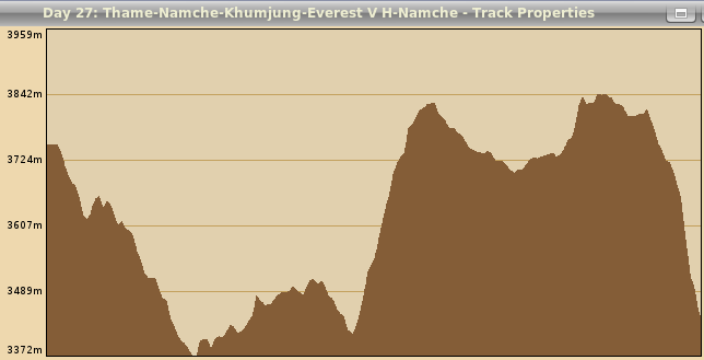
Here is an overview of the trek data, where the length and elevation information is given in meters. Click on the day number to view the elevation profile.
| Day number | Place names | Date | Begin time | End time | Duration in hours | Distance in meters | Minimal elevation | Maximal elevation | Elevation gain | Elevation loss |
|---|---|---|---|---|---|---|---|---|---|---|
| 01-28 | Jiri-Khumbu-Lukla (total w/o bus&plane) | Oct 24-Nov 20 | 13:49:40 | 18:19:24 | 28 days | 328445 | 1535 | 6179 | 23823 | 22871 |
| 01 | Kathmandu bus terminal-Jiri | 2008 Oct 24 | 05:59:43 | 13:49:35 | 07:49:00 | 153784 | 582 | 2627 | 5515 | 4409 |
| 01 | Jiri-Shivalaya-Deurali | 2008 Oct 24 | 13:49:40 | 19:21:50 | 05:32:00 | 12525 | 1750 | 2625 | 1477 | 724 |
| 02 | Deurali-Kinja-Sete | 2008 Oct 25 | 08:06:20 | 16:45:00 | 08:38:00 | 12008 | 1535 | 2644 | 1148 | 1245 |
| 03 | Sete-Junbesi-Phurteng | 2008 Oct 26 | 06:30:00 | 16:30:00 | 10:00:00 | 14182 | 2552 | 3529 | 1340 | 850 |
| 04 | Phurteng-Taskindu La-Nunthala | 2008 Oct 27 | 08:30:00 | 14:30:00 | 06:00:00 | 8602 | 2202 | 3068 | 470 | 1310 |
| 05 | Nunthala-Kharikola-Khari La | 2008 Oct 28 | 07:20:00 | 15:20:00 | 08:00:00 | 8756 | 1552 | 2828 | 1280 | 650 |
| 06 | Khari La-Chheplung-Phakding | 2008 Oct 29 | 07:00:00 | 15:08:11 | 08:08:00 | 14912 | 2299 | 2939 | 765 | 1052 |
| 07 | Phakding-Namche Bazar | 2008 Oct 30 | 07:34:31 | 12:10:37 | 04:36:00 | 9491 | 2595 | 3407 | 1010 | 195 |
| 08 | Namche Bazar | 2008 Oct 31 | 13:48:55 | 14:28:06 | 00:39:00 | 775 | 3440 | 3549 | 79 | 109 |
| 09 | Namche-Tengboche-Dingboche | 2008 Nov 01 | 06:10:06 | 15:28:49 | 09:18:00 | 17986 | 3266 | 4297 | 1575 | 685 |
| 10 | Dingboche-Chukhung Ri-Dingboche | 2008 Nov 02 | 09:35:07 | 16:53:43 | 07:18:00 | 13555 | 4310 | 5520 | 1271 | 1276 |
| 11 | Dingboche-Chukhung | 2008 Nov 03 | 11:03:08 | 14:15:43 | 03:12:00 | 4936 | 4303 | 4689 | 438 | 88 |
| 12 | Chukhung (rock training) | 2008 Nov 04 | 09:00:00 | 11:00:00 | 02:00:00 | 144 | 4692 | 4750 | 58 | 58 |
| 13 | Chukhung (ice training) | 2008 Nov 05 | 08:49:30 | 15:03:18 | 06:13:00 | 6292 | 4695 | 4968 | 336 | 339 |
| 14 | Chukhung-Island Peak Base Camp | 2008 Nov 06 | 12:37:40 | 15:04:35 | 02:26:00 | 5824 | 4798 | 5065 | 336 | 69 |
| 15 | Island Peak-Chukhung | 2008 Nov 07 | 02:34:10 | 14:53:27 | 12:19:00 | 11166 | 4701 | 6179 | 1121 | 1571 |
| 16 | Chukhung-Dingboche-Lobuche | 2008 Nov 08 | 06:35:35 | 15:47:34 | 09:11:00 | 11636 | 4303 | 4893 | 706 | 518 |
| 17 | Lobuche-Everest BC-Kala Patthar-Lobuche | 2008 Nov 09 | 06:51:40 | 17:32:36 | 10:40:00 | 20734 | 4873 | 5600 | 1236 | 1208 |
| 18 | Lobuche-Cho La-Thagnak | 2008 Nov 10 | 07:10:33 | 15:03:13 | 07:52:00 | 13658 | 4661 | 5327 | 872 | 1106 |
| 19 | Thagnak-Gokyo-Gokyo Ri-Gokyo | 2008 Nov 11 | 07:17:55 | 18:05:32 | 10:47:00 | 7497 | 4649 | 5319 | 860 | 794 |
| 20 | Gokyo-Knobby View-Gokyo | 2008 Nov 12 | 07:19:49 | 14:25:38 | 07:05:00 | 14011 | 4720 | 5472 | 1003 | 974 |
| 21 | Gokyo-Renjo La-Lungden | 2008 Nov 13 | 07:46:30 | 13:33:22 | 05:46:00 | 10078 | 4329 | 5353 | 679 | 1060 |
| 22 | Lungden-Sumna-Kangchung | 2008 Nov 14 | 07:14:20 | 17:11:12 | 09:56:00 | 17907 | 4315 | 5226 | 1171 | 275 |
| 23 | Kangchung-Nangpa La-Kangchung | 2008 Nov 15 | 06:19:20 | 16:18:23 | 09:59:00 | 15598 | 5143 | 5686 | 789 | 786 |
| 24 | Kangchung-Arya | 2008 Nov 16 | 07:54:38 | 16:14:38 | 08:20:00 | 15981 | 4333 | 5238 | 270 | 1150 |
| 25 | Arya-Thame | 2008 Nov 17 | 08:24:45 | 11:51:23 | 03:26:00 | 10564 | 3769 | 4328 | 135 | 686 |
| 26 | Thame-Sundar Peak-Thame | 2008 Nov 18 | 07:45:00 | 15:43:24 | 07:58:00 | 7873 | 3772 | 4985 | 1266 | 1275 |
| 27 | Thame-Namche-Khumjung-Everest V H-Namche | 2008 Nov 19 | 07:40:02 | 18:09:26 | 10:29:00 | 17390 | 3372 | 3842 | 890 | 1204 |
| 28 | Namche-Phakding-Lukla | 2008 Nov 20 | 07:08:13 | 18:19:24 | 11:11:00 | 18776 | 2544 | 3528 | 705 | 1332 |
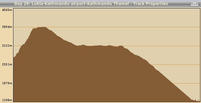
| 29 | Lukla-Kathmandu airport-Kathmandu Thamel | 2008 Nov 21 | 07:49:26 | 11:47:53 | 03:58:00 | 149680 | 1208 | 3894 | 1853 | 3296 |


