

See also the Sellaronda on skis, covering roughly the same area.
| | Total time: | about 3 days |
| Total length: | about 50 km | ||
| Total ascent: | about 4000 m | ||
| Total descent: | about 3600 m |
Total ascent: about 700m, total descent: about 400m

 Begin of the tour at 09:50, after four hours of driving from Munich. My mountaineer mates Thomas, Martin and Gabor have just finished packing. Unfortunately, it was rather cloudy. |  The rock climbing path is quite difficult, but very interestingly arranged. We had a considerable amount of luggage: each about 18 kilos! Carrying the big and heavy backpacks turned out to be quite an obstacle. |  Depending too much on the strength - or shall I better say: weakness? - of the arms (rather than feet) in the almost vertical parts resulted in premature exhaustion. We were glad to balance the resulting extra risk by using a short rope and carbine (snap hook) attached to the fixed steel rope. |  The upper part of the trail was much easier and displayed some fancy rock formations. |
 Finally at the top, we had a first fantastic view of the Sella plain into which some steep valleys carve. View of Sass Pordoi. |  After a rather boring horizontal hike, we reached the Valun di Pisciadù with the lake and the hut of the same name. |  Shortly after arrival (at about 17:00) there was a short - not very promising - rain shower, but then the sun came out again! |  This gave us the opportunity to perform some glacier rescue exercises. |
Total ascent: about 1700m, total descent: about 1400m
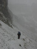 Thursday started with a bad surprise: snow flurry. However, since the weather forecast promised strong improvement, at about 8:30 we decided to depart in order to get into a good position for the climbing adventure planned for the afternoon. |  Even normally simple climbing turned out to be difficult with the presence of ice. |  About one hour later, it suddenly began to clear up! |  The bright sun on the thin perfectly white snow cover was just awesome. |
 Time to apply some sunscreen... |  ...and to admire the great scenery shaped by the Creator. Note the dark green hills in the lower sections. |  Piz Boè calling us for a visit |  Some happy mountaineers in front of Val Lasties. By the way, the walking sticks help not only to protect the knees (thanks God, this time I did not have any pain in my right knee!) but also to save forces by shifting part of the burden of walking to the arms. |
 Yes, sure we saw the Yeti ;-) |  One of the most stunning formations of the Dolomites: Dent de Mesdi(?) at the western edge of the Val de Mesdi |  Final run on the hut |  Cool beer for the cool guys (actually, only borrowed from some other crazy Bavarians) |

 The walls of Cresta Stren (just north of Piz Boè) as seen from the sunny table in front of the hut |  Nice insights into… …the Prei de Pordoi, |  Val Lasties, |  Val Mesdi (Mittagstal), |
 the high plain of the Sella massif, |  Lech Dlace (icy lake), |  the mountain flora, |  and mountain fauna ;-) Note the dogs in the rucksacks! |
 Our first view of mount Marmolada, still too shy to reveal its head… |  Just scratching Rifugio Franz Kostner al Vallon, with the wonderful Kreuzkofelgruppe in the background |  Any free climbing volunteer? |  Finally, Marmolada admits unhindered views |
 World War I memorial and the winding Pordoi pass road |  Head of "one of the most difficult rocks climbing trails of the Alps" |  Yes, at least the beginning is very tough! Two of 40 Czech mountaineers, visiting the Dolomites like us, considered giving up - fully understandable because of their very heavy backpacks. |  We started climbing at 15:50, and while we found out that at least with our light day packs, after the first few metres the trail is quite well manageable, Tom is still suspicious. |
 Finally, we were able to persuade him… |  …and he did very well! |  A swinging bridge of iron rope delights the one and scares the others. |  Waahoo, I've made it!! |
 Next the end of the dangerous part of the trail, the climbers are rewarded with some fancy rock formations. |  Martin, the one of us with the most climbing experience, with the Marmolada summit in the background |  Surprisingly (i.e., even without any training this year), I turned out to be the physically fittest of our group. So I decided to work out myself a bit… |  …and reached the summit at 17:50 - half an hour before the others. |
 Visibility is fine: The central-alpine Zillertaler mountains in the North |  Mighty mount Pelmo is greeting from the East |  Further members of the Czech group :-) | 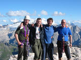 Re-united with the others, celebrating the highest summit of the Sella massif, and looking forward to tackling the Marmolada summit two days later |
 Eager to have some dinner, we headed down to the Boé hut, |  passing a fascinating sculpture reminding me of a ship stern. |  I ate outside the hut in the evening sun, which had the disadvantage of cooling the food very quickly, |  but the advantage of offering some nice opportunities to make strange pictures. |
 I had decided to climb the 300 m up to the peak again in order to enjoy the sunset there. |  |  |  The cute Cap. Piz Fassa sitting at the top like an eagle's nest |
 Back to the summit again |  Tofana group to the east |  The pyramid-shaped shadow of Piz Boé in the foreground, mount Pelmo and the Civetta group in the background |  The Geisler peaks (left) in the North |
 Heiligkreuzkofel (left), Großglockner (middle, far back) in the Northeast |  Marmolada, with glowing foreground… |  …and slightly glowing itself |  Geisler peaks below some pink cloud stripe |
 The only other knowing person (from Franconia, also Southern Germany)… |  Sunset against Langkofel (Sassolungo) to the left and the hut to the right |  |  |
 … withstanding the cold, taking tons of pictures, exchanging his polarizing filter, and talk-shopping with me | 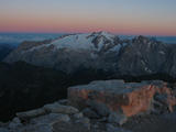 Good night, Marmolada |  Good night, Geisler peaks |  Good night, Langkofel |
Total ascent: about 750m, total descent: about 1000m
 Packing our stuff after a more or less comfortable night, with people snoring etc. |  Having breakfast in the usual way: boiled tea water bought from the hut, and consuming our self-brought bread, sausages, chocolate, - and even butter! |  Clouds (or: fog, if you prefer) along the short stroll (40 minutes) to Forcella Pordoi |
 The two cable cars meeting on the way to/from Sass Pordoi |  Just scratching civilization at Passo Pordoi with its loads of day tourists |  Trying to spot the climbing route of the ''Cesare Piazzetta'' in the middle |

 The upper station of the cable-car line now fully visible |  Panoramic view of the Sella massif |  Alpine "spring" flowers | |
 Soaking up the poor sun at that day |  The famous lovely Viel dal Pan (Bindelweg) at unfortunately not very lovely light conditions | 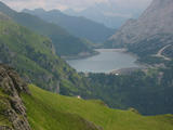 Same with the Lago di Fedaia |  Fire lily |
 Distribution of work: Tom was fetching the car from Passo Sella (if we had planned this in advance, we would have avoided carrying all the heavy glacier gear - rope, ice-axes, crampons - across the Sella massif!), me hiking the 600 metres up to the hut at the upper end of the cable car, and the remaining two taking the easy (and not even expensive) way |  Dinner at the restaurant there - apparently a very old photograph |  Fantastic frightening cloud formations on Langkofel, Passo Pordoi, and Sella |
 After half a litre of wine each (white or red, according to personal preferences), |  some turned crazy, |  others sleepy. Well, this night all of us had the best sleep of the three nights in the mountains. Probably partly because we were most adapted to the height meanwhile, and surely because of the effect of the alcohol which we had taken into account deliberately. |
Total ascent and descent: about 800m (excluding cable-car)
 Around 3:00, I already woke up, and when I went down to the restaurant an hour later, I noticed that, miraculously, it had cleared up! |  The upper station just around the corner of the restaurant |  Again an hour later, I felt brave enough to wake up the others. I admit I even had been tempted to start the ascent to the Marmolada alone long before sunrise, in order to catch it on the way up and to be sure that the clouds would not obstruct visibility again | 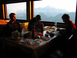 Martin told us that he had an aching tooth since the day before, and was considering to skip the Marmolada experience. We prayed for him and gave him medication against pain and tumefaction, and then, fortunately, he felt fit enough to come with us. |
 Langkofel group on the early sunlight |  On departure at 6:20, the weather looked very promising. |  In order to take the Western rim to the top, we first had to descend a bit, before ascending via a big snow field… |  …and reaching the Forcella della Marmolada (2896m). |
 On climbing the wonderful trail full of steel ropes, iron nails and ladders, etc., the clouds gradually won the battle against the sun. View toward West… |  and East (facing the summit to the right). Note the effect of the wind. |  Most time, it was even more cloudy than this, |  with a few very short exceptions on the big snow field close to the summit. |
 Viewing to the North, one could imagine of being in a snowy desert, |  while viewing to the South, with walls leading downwards about 600 metres almost vertically, gave a quite different picture. |  At 9:30, I was the first to reach the summit (having hurried in the - partially successful - hope to catch at least a few holes within the clouds), |  and 20 minutes later we could wish each other "Berg Heil" and take the obligatory documentation picture (with self-timer). |
 Right next to the summit is a small protection hut… |  …with more or less pleasant - yet at least wind-protected - interior… |  …and guaranteed smell-free sanitary facilities! |  As a further curiosity, we met an astronaut, which after some interrogation turned out to be one of our group: Gabor ;-) |
 On the way down straight Northwards, we had to cross (climbing almost freely) down a 200 metres rocky flank, the actual difficulty of which is still under debate. |  At least, we were united to try not to climb or fall into… | 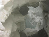 …the cracks of the glacier we had to cross for several hundred metres down, |  and thus took the time to put on our gear (except for Martin, who not only knew - like me - that the whole thing was of rather limited danger, but was unscrupulous enough - unlike me - to confront the others with this view). |
 Sometimes it was possible to see the hut (half-way downhill) and even the lake (down in the valley) |  At the more steep and icy sections, Gabor had the opportunity to make use of his brand-new crampons. |  Long horizontal crack right below the eastern rim |  Note the caves, apparently built during the war |
 A little stream down the lower ice & snow field |  Close-up |  Other groups doing exercises |  The long time we spent on packing our glacier gear was the ultimate test for Martin's patience, in particular with his tooth that had started aching again |
 Water supply for the hut - the water was quoted to be not drinkable, but I am the living proof that this is not true :-) |  The upper hut, Rifugio Cap. al Ghiacciaio, with protection against the forces of the glacier |  The upper station of the cablecar and lower hut where we had spent the night |  Some beer worshippers (in the restaurant of the lower hut) |
 Perfect timing - when we left, small hail started falling |  Last panoramic view of the Sassolungo and Sella massifs |  Martin and Tom waving at me, their successor |  Gabor waving at his pre-pre-predecessor |
 The eastern half of the lake |  The old (meanwhile officially unused) part of the trail I had followed upwards the day before |  Approaching the lower station |  Hintze's Shuttle Service Ltd ;-) There is just one thing that we were glad to have carried it around uselessly: the first-aid kit. Thanks God, we did not have any injuries. |
 Still being in Italy, concluding the tour in a pizzeria was a must. The people of Osteria Obelics were absolutely friendly… |  …and their food just delicious! The perfect compensation for more or less basic food underway - on return home, I noticed to have lost 3 kilos within the four days! |  Aerial photo of the Sella massif, reminiscent of a fortress, towards North-East |  The massif of the Marmolada from the North-East |